Get To Know a County: Broadwater County

As a child, I believed that Broadwater County took its name from the Canyon Ferry reservoir, which at that point was the broadest water I had ever seen. Imagine my disappointment on learning that the county took its name from a real person, Charles Arthur Broadwater. When the Montana Legislature created Broadwater County on February 9th, 1897, as the state’s twenty-fourth county, Charles Broadwater had been dead for five years. A true Montana pioneer, he got his start in Bannack, where he became involved in transportation, politics, and real estate.
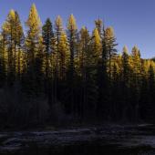
Today, the county that bears his name covers 1,239 square miles of which 46 are water. The 2020 census counted 6,774 residents, the highest in the county’s history. The county’s population has almost tripled since 1970 when the census counted fewer people than in 1900, the first census after the county’s creation. Much of this recent growth is due to census-designated places on the county’s northern and southern ends. Spokane Creek, Winston and the Silos all serve as bedroom communities for Helena, while Wheatland in the south serves the same function for Bozeman.
Wheatland makes for an interesting case study. Not incorporated as a town, it nevertheless has the second highest population of any place in Broadwater County. The 2020 census counted 636 residents, and the 2023 estimate is 705, with a growth rate of over 10% annually. Median age is 37.3, and average earnings come in at $60,100, while Broadwater County’s figures overall are 47.1 and $36,057. Average household income is $95,613. WorldPopulationReview.com finds that there are no rental properties in Wheatland; rather 100% of local homes are owner-occupied. Over eighty-six percent of residents have at least some college, and over thirty-eight percent have a bachelor’s or graduate degree.

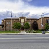
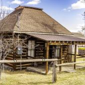
The largest, and only, incorporated city in Broadwater County, Townsend has served as county seat from the beginning. Founded in 1883 and named for the wife of the president of the Northern Pacific Railroad, the town served as a shipping point for the mines that surround the area. The 2020 census counted 1,787 residents, down 4.8% from the 2010 count (highest in the county’s history). Two of Broadwater County’s eleven listings on the National Register of Historic Places are in Townsend: the State Bank of Townsend at 400 Broadway, and the Valley Masonic Lodge at 131 South Spruce Street.
In addition to the county seat, Broadwater County has six communties, all classified as Census Designated Places. Of the six, two are historic towns south of Townsend. Radersburg, with a 2020 population of 61, was the childhood home of actress Myrna Loy. Loy’s mother preferred southern California to rugged Radersburg and took her daughter back and forth between 1912 and 1918 when she moved to California permanently. The future actress may have attended school at Radersburg, whose school opened in 1913 and closed in 1966 with students going to Toston. Radersburg is also home to a Methodist church that Brother Van (William Wesley Van Orsdel) opened in 1914.
Ten miles east of Radersburg, Toston sits on the banks of the Missouri River just off U.S. Highway 287. The truss bridge that crosses the river is on the National Register. Toston, like Radersburg, owes its existence to the gold mines in the nearby hills. The Toston Smeltering Company processed ore for a short period in the late 1800s, but that was long enough to bring in a population that stayed on and farmed the area. With a 2020 census count of 100, Toston today is little more than a ghost town, but one more accessible than most. And as for the school? Any children from Radersburg and Toston now attend school in Townsend.

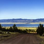
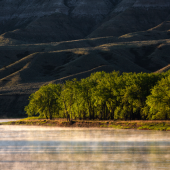
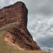
Spokane Creek (2020 population 355), Winston (169), and The Silos (691) lie along U.S. Highway 12/287 19, 13 and 5 miles north of Townsend respectively. To my eye, Winston is the only one that looks like a town, and indeed it has a post office that opened in 1892. The Silos takes its name from one of the most notable features in Broadwater County. Driving between Helena and Townsend, you cannot miss the two brick towers that rise between the highway and the lake. Montana historian and blogger Carroll Van West mentions how rancher A. B. Cook built the silos around 1920 to serve his sheep ranch. The ranch itself succumbed to the Canyon Ferry Reservoir in the mid-1950s, but the silos live on. They now mark an ever-growing residential area that includes a campground and marina on the lake.
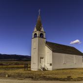
Two Missouri River communities no longer exist. North of Townsend, and on the east bank of the river, the Canton Valley was a thriving farm community until the waters behind the Canyon Ferry dam flooded the entire valley. St. Peter’s Catholic Church was moved before it disappeared under the water and now stands, overlooking the lake, just a few miles outside Townsend.
Lombard, south of Toston, began as the southern terminus of the Montana Railroad. When that line became part of the Milwaukee Road, Lombard carried on as the point where the Milwaukee and the Northern Pacific lines crossed. Home to several businesses including a hotel, Lombard failed to thrive and its post office closed in 1957. Today a few concrete foundations and an abandoned bridge are all that’s left of Lombard. When I drove there in 2021, the road from Toston was a difficult trek across the mountains, even in my Ford Explorer. I don’t recommend the journey unless your vehicle has a sturdy undercarriage.


Leave a Comment Here