David Thompson’s 1810/1812 Sketches of Montana’s Mission Mountains

Artist’s rendition of Saleesh House, by Cricket Johnston. Sketch provided and used with permission by
Carl Haywood, http://www.rockmanstradingpost.com.
Distinctly Montana has just published their winter issue which contains a story I wrote about the early nineteenth-century explorer and fur trader, David Thompson and his time in Montana from 1809-1812. [here] This post is meant as an addendum to that article, to cover one other aspect of his Montana story that couldn’t be included in the magazine article due to space considerations. There is so much more to the story of his life and accomplishments and several books have been written that cover his life in much more detail.
On top of his other skills, David Thompson was also a prolific sketcher. He would draw pencil sketches of many places along his travels and later fill them in with pen and water colors. His sketches have a particular style. He wasn’t so much trying to record what he was seeing, as say, an artist like Thomas Moran did for the Hayden Expedition to Yellowstone in 1870. Rather, he was more concerned with representing the geology and structure of the mountains he was sketching. As a result, his sketches have a unique style and must be understood within this context. Of all the many sketches he made over his lifetime, only 10 are known to have survived and are housed in a museum in Toronto. Four of those are of Montana’s Mission Mountains. While Thompson may not have been the first European to see the Mission Valley and Flathead Lake, he was the first to give an account of them and actually sketch them.
The Mission Valley is where I live, and, being a photographer, I was especially interested in these sketches and in identifying where he was when he sketched them, as well as matching his sketches to present-day photographs. Through this, I have developed a personal connection to a story that is now over 200 years old. Apparently, this has never been done before with these sets of sketches, which made this enterprise even more exciting. Here is a little historical perspective first from his journals taken from Catherine White’s “Journals of David Thompson”.
David Thompson was a very busy man and very occupied with his fur trading responsibilities from his Saleesh House base near today’s Thompson Falls. However, his true passions were exploration and map making, and at these, he was a true expert. Just look at how accurate his 1814 map is compared to today’s Google maps. He even accurately included areas he had never visited!

Side by side comparison of a small section of a lithograph of Thompson’s original 1814 map with current Google Map of northern Idaho/western Montana. Lithograph provided and used with permission by Carl Haywood, http://www.rockmanstradingpost.com.
In the last week of February, 1812, Thompson had just enough time for one more exploration before it would be time to head back east with his season’s worth of furs, never to return to Montana again. His journals describe that on February 26, 1812, he and a Kootenai companion named La Gauche (“Lefthand”), struck out east from the Salish Camp near present day Dixon, along what is now called Mission Creek. He then headed south through the current Arlee and Evaro areas until he came to a location close to where Highway 93 crosses I-90, a little west of Missoula. From there he made his customary compass and sextant readings. He could see far down the Bitterroot Valley, as well as up the Clark Fork to the east. He commented on being able to see the trail that Lewis and Clark had used on their travels through there before him:
“from the forks of Courter’s Branch with the Southern Branch (confluence of the Clark Fork and the Bitterroot Rivers), by which Captain Lewis came, joined before me….from about 6 miles beyond there is a defile (canyon/steep valley) by a bold brook (Lolo Creek), up which Capt Lewis went...”
He noted in his journal that he made some sketches of the area (since lost). He did not travel any further south, even though he must have known that the main Salish camp was on the Bitterroot River near present day Stevensville. He did note that the weather was turning bad:
“the bad weather gathering prevented me from going farther and the country is rapidly thawing, the horses sink deep every step and fatigue much”.
He must have felt great disappointment. For so many years he had focused on trading with the Salish. Though he constantly traded with the Salish Camp near Dixon, he must have really wanted to reach the tribe’s main camp. The weather would not let up, though:
“...very bad weather the evening and night and no shelter, I passed much of the night standing leaning against a tree..”
He returned to his camp on the Flathead River the next day, near the Salish Camp at Dixon, and notes that the weather continued to be miserable – cold and wet. However, March 1st first broke to be “a fine day, but very sharp night and morning”. By 9:10, he was off again. He had heard about a large lake north of there and he wanted to see it so he could include it on his grand map. Again, traveling with La Guache, they headed north past the future sites of Charlo and Ronan, and they rode up a small knoll to the southwest of the Polson area (“Goose Hill” aka “Pilot’s Knob”).
“...we came smartly on trot and hard gallop to 1:25 PM when we alighted on the top a bare knowl, commanding a very extensive view of the lake and country far around.”
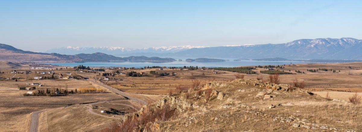
This “knowl” certainly does provide a commanding view of not only Flathead Lake below, but all the way north to the mountains on the south side of Glacier National Park. To the south, one can see the whole of the Mission Valley and past the end of the Mission Range to Lolo Peak south of Missoula. Again, he paused to take bearings, etc. and to make several sketches of the area. In all, he spent about an hour and a half there.

NW view of Goose Hill (aka "bare knowl")
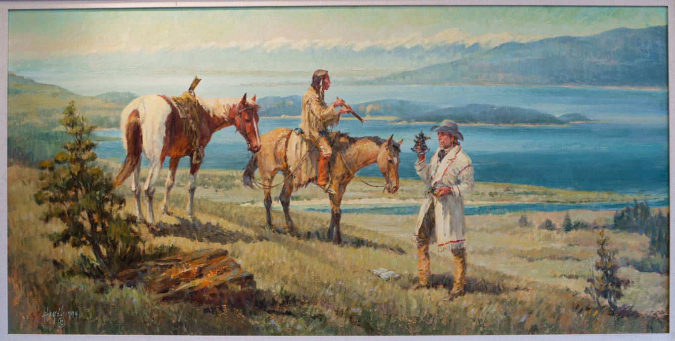
"David Thompson Explores to Saleesh (Flathead) Lake March 1, 1812"
Paining by Frank Hagel (used with permission)
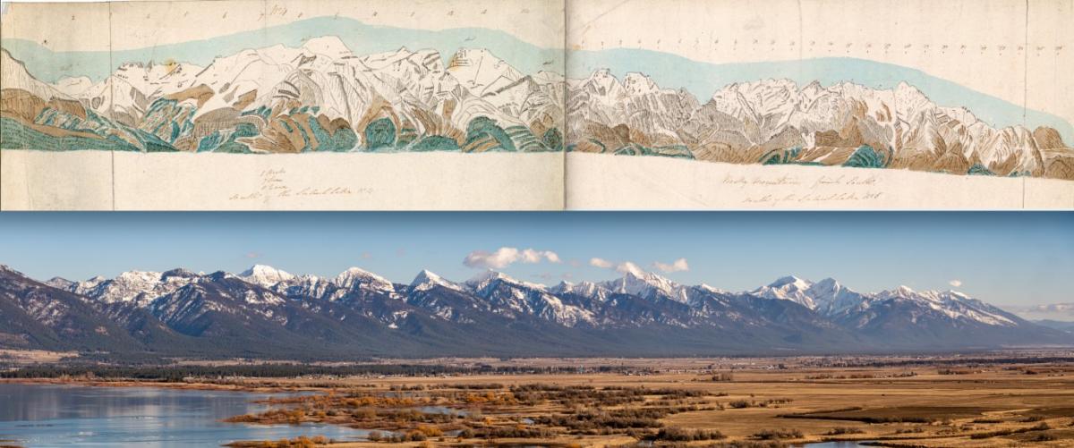
“Sketched off the lake, etc.”
“The scenery on the east side the lake is not striking, a sameness of hills….”
This is a very apt description of the north end of the Mission Range as they taper down to nothing by Big Fork, around which the Swan River enters Flathead Lake.
Two sketches from this observation point survive. I have a panorama of the Mission Range from the top of this hill and matched it to these two sketches. These sketches are labeled by Thompson as “No. 4” and “No. 5”. Unfortunately, 1-3, which probably were of Flathead Lake, have apparently been lost. Sitting up there on that hill, knowing I was on the exact spot where Thompson and La Guache first sighted Flathead Lake made these drawings was pretty cool!
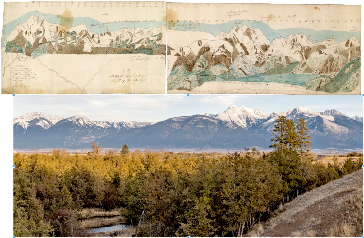
While it can be determined that the sketches above were made on March 1st. 1812 from Goose Hill, the date and exact location of the other set of two sketches are uncertain. What is clear is that they are from the area just above the confluence of Mission and Post Creeks, on what is now the National Bison Range. It is likely they were sketched at the end of February, 1810, but no-one can know for sure, as there are no journal entries that mention these sketches. Also, there was probably another sketch to compliment these, as the southern end of the Mission Range is missing.
As I said at the beginning of this, I feel a personal connection to these 4 sketches. These are not sketches of some abstract place I have never been to, like those of his Kootenai House in Canada and the mountains around there. This is where I live and I see these landmarks every day and now, I cannot help but feel his presence here, even today.
More information on David Thompson, his life in Montana and a deeper discussion of these sketches can be found here.

“David Thompson Taking an Observation”, Illustration by C.W. Jefferys, Library and Archives
Canada, Acc. No. 1972-26-1406. Sketch provided and used with permission by Anthony Allen, Digital
Curator, https://www.cwjefferys.ca Drawing shows Thompson using his sextant with a cover tray of mercury as an "artificial horizon".
- Reply
Permalink