The Beartooth Highway: Then and Now

Photo by Holly Matkin
When I reminisce about the stand-out, all-time-favorite drives I’ve been blessed to experience in my life, essentially every one was viewed from the passenger seat of a 900-pound Harley-Davidson. Even roads I cherish driving by car – like the epic Going to the Sun Road in Glacier National Park – were stunningly different experiences on the back of a motorcycle. The combination of speed and unencumbered openness produces an intoxicating array of sights and scents and temperature fluctuations that utterly bombard the senses, eradicating all thoughts and seamlessly introducing the rider to the simple pleasure of fully experiencing this single moment in time.
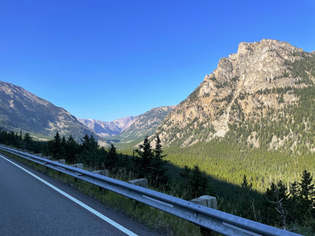
Photo by Holly Matkin
A Voyage Over the Top of the World
The Beartooth Highway, also known as U.S. Highway 212, traverses an impressively diverse range of ecosystems that are predominantly frozen nine months of the year. Drifts as high as 26 feet have been recorded in some areas of this pristine wilderness, and clearing snow from the roadway for the short summer tourist season can take months. With a lot of skilled manpower and a bit of good luck, the road is generally open Memorial Day through mid-October.
The highway begins approximately nine miles south of the Carbon County seat of Red Lodge on the east side of the Beartooth Range.
We set off on our journey with the first hint of morning beginning to glow on the horizon. Even in the middle of August, an exhilarating chill punctuates the air during those break-of-dawn moments at this altitude.
The bulk of the historic coal-mining town was not yet awake, but as we made our way down the main street, a handful of other riders fell in line ahead of us and behind us every few blocks, all smiling or nodding “good morning” to one another as if they were old friends. Though we’d never met, our shared anticipation for the voyage ahead seemed to give us an innate sense of comradery.
Heat from the rising sun crept across our leather jackets, slowly warming our bodies and pulling the coolness from the morning dew up into the sky as we began our steady ascent through Rock Creek Canyon.
The roadway soon folded in layers before us, climbing in elevation with every hairpin turn. Separated from the canyon floor by merely a strip of steel guardrail, the spectacular panorama of untamed wilderness spilled out below as we rose – rugged, pristine, and impossibly glorious.
The forest of lodge pole pines unveiled more of the Beartooth’s soaring peaks and stark-white glaciers as the serpentine strip of asphalt wove its way up the mountainside. We marveled at the tumbling waters of upper Rock Creek now far below us while gazing in wonder at the expansive canyon and the sweeping tundra of Silver Run Plateau and Hellroaring Plateau.
The curves of the tightly-curled switchbacks still bear the names of the men who constructed them back in the early 1930s. Names like Frozen Man Curve, Deadman’s Curve, Mae West Curve, and Primal Curve give us a glimpse into how those workers must have viewed the massive feat of engineering they were helping to undertake.

Photo by Holly Matkin
The Birth of the Bitterroot, and the Survival of Two Cities
The Rock Creek Valley and the Beartooth Mountains were part of the Apsaalooke Indians’ aboriginal territory. Indigenous peoples traveled through the mountain range for at least 12,000 years before early explorers, trappers, and miners followed suit. In 1881, while traveling to Yellowstone National Park, Civil War general Phillip Sheridan and a 120-man escort trekked across a portion of what would later become the path of the roadway.
The Rocky Fork Coal Company set up a coal mine operation at the foot of the Beartooths in 1886, which became the birthplace of present-day Red Lodge. Meanwhile, miners struck gold on the other side of the mountains, leading to the establishment of Cooke City.
Just over 4,500 people called Red Lodge home by the 1920s, but an increasing reliance on natural gas, cheaper and easier-to-access coal deposits in other areas, and low overall coal prices caused the area’s coal mines to close their doors during the early part of the decade. Unemployment rates soared, and the city was on the verge of collapse.
Cooke City’s silver, copper, and gold mines were booming, but finding a way to profitably ship ore out of the mining district had become a problem. Mine owners had little choice but to haul the ore over a 60-mile road to the railroad terminal at Gardiner – a route that took them through a section of Yellowstone National Park. The transports were destroying the road and interfering with tourist traffic, so all parties involved had a vested interest in finding an alternative solution.
For much of the 1920s, proponents from both Cooke City and Red Lodge lobbied the U.S. Congress to fund a new approach from Red Lodge into Yellowstone National Park. Much emphasis was placed on the benefits of being able to haul timber and to access the riches of Cooke City – both of which were revenue sources for the federal government. Creating a new entrance for tourists to enter the park was initially far less of a selling point.
Debates over the proposed roadway went on for years and the idea of connecting the cities teetered on the edge of failure more than once.
The highway’s fate was sealed in the wake of the 1929 stock market crash and the ensuing Great Depression. When President Herbert Hoover signed the National Park Approaches Act in January of 1931, the route between Red Lodge and Cooke City was the first park road to receive funding, according to the Federal Highway Administration.
The first contracts were awarded five months later and construction on the roadway began that summer, providing essential economic boosts to Yellowstone National Park and both mountain communities. Despite the grueling conditions, treacherous terrain, two deaths and logistical and engineering difficulties, the $2.5 million roadway was completed on schedule in 1936 for slightly less than half of what the federal government had expected.
Visitors came from as far as California and Maine to be among the first to take a trip over the top of the world on June 14, 1936. An average of 400 vehicles were traveling the new roadway each weekday by 1939. The number soared to well over 1,000 per day on weekends and holidays.
“The Beartooth Highway opens a window in the spectacular scenic and natural environment of an alpine ecosystem that might not otherwise be available to most Americans,” Montana Department of Transportation historian Jon Axline writes. “The Beartooth Highway is also a story of man versus nature in its construction. It was no easy task…”
The Federal Highway Administration designated a significant portion of the roadway as an “All American Road” in 2002 due to the highway’s cultural, scenic, and historical significance. It was added to the National Register of Historic Places in 2014.

Photo by Holly Matkin
The Rest of the Trip
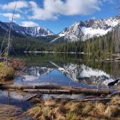
The highway crosses the 45th parallel approximately 30 miles outside of Red Lodge, marking the halfway point between the equator and the North Pole. We pulled off soon thereafter to take in the beauty of cerulean waters of the Twin Lakes, cradled majestically by the rocky swath of valley below.
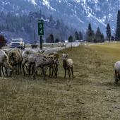
They are but two of the 950 alpine lakes that lie within the 943,377-acre Absaroka-Beartooth Wilderness, which contains the Beartooth Mountains. The area boasts 20 peaks over 12,000 feet, to include Montana’s highest point, Granite Peak, at 12,799 feet. A lavish display of Indian paintbrush, columbine, shooting stars, and various other wildflower blossoms bedazzle the tundra in June and July.
The jagged, volcanic peaks of the Absaroka Range broke over the horizon as we rode past the Beartooth Basin ski area, which first opened in the 1960s and is one of the oldest alpine ski training areas in North America.
Off in the distance, we could see the sharp spire of “Na Piet Say,” the Apsaalooke (Crow) Indians’ name for “bear’s tooth,” stabbing skyward just before we reached the 10,947 West Summit overlook approximately 1,000 feet above the tree line.
We bailed off the bike and promptly scrambled up a jumbled mass of scattered rock (which initially seemed much closer than it actually was), reaching an even better vantage point to take in a 360-degree panorama.
The plateau is comprised of gneisses, granite, and schist that formed approximately 3.3 billion years ago, according to Axline's book, The Beartooth Highway: A History of America’s Most Beautiful Drive. They are the oldest exposed rocks in all of Montana, and are among the oldest known in the world. It was a display of natural grandeur so astonishing it is still difficult to comprehend. I’m not sure if it was due to the impromptu high-elevation hike or the majesty of the view, but I was unquestionably left breathless.
The Beartooth Highway continued on into Wyoming at the top of the Beartooth Plateau, then dropped into a long, gradual descent past mountain lakes, waterfalls, and boulder-laden meadows. Index and Pilot Peaks of Wyoming’s Absaroka Range stood out sharply against the sky as we crossed back over the border into Montana, closing in the historic mining town of Cooke City. The northeast entrance to Yellowstone National Park sat just four miles beyond.
Even before doing much research about the ruggedly wild, 68-mile Beartooth Highway between Red Lodge and Cooke City in south-central Big Sky Country, I knew I had wanted to see the adventure from the seat of a Harley.
At nearly 11,000 feet, the sprawling alpine tundra at the height of the Beartooth Pass has been referred to by many as the “Top of the World.” What better way to experience the harrowing thrill of driving one of the highest-elevation roadways in the United States than from the back of a motorcycle?

Photo by Holly Matkin


- Reply
Permalink