Get To Know Big Horn County

With the creation of Montana Territory in 1864, all land east of Bozeman Pass was called Big Horn County. So few settlers lived in this vast area that the entire eastern part of the state fell under Gallatin County's jurisdiction. In reaction to the defeat of the 7th Cavalry at the Little Big Horn, the Montana Territorial Legislature renamed the "county" in memory of General Custer. Over the next thirty-seven years, the legislature set up eight counties in this vast area, the eighth being a new Big Horn County (January 13th, 1913).
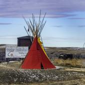
Big Horn County has retained its 1913 borders and today covers 4,995 square miles, making it the sixth-largest county in the state. With a 2020 population of 13,124, it was the fourteenth most populous county in Montana. Its county number is 22. The Crow and Northern Cheyenne Reservations cover over 70% of Big Horn County. The U.S. Census Bureau's 2021 estimates show 66.7% of the county's population is Native American. Only 28.4% consider themselves "white." The Crow Tribe has been better than most Native groups in keeping their language alive. The same census estimates indicate almost 27% of Big Horn County's population spoke Crow at home. (As a comparison, Glacier and Roosevelt Counties, the only other Montana counties with over 60% Native populations, show 4.5% and 4.1% speaking languages other than English at home.)

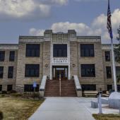
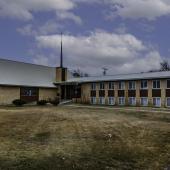
Founded in 1907 and incorporated in 1911, Hardin not only serves as county seat, but is the largest and only incorporated city in the county. The 2020 Census counted 3,818 city residents. Hardin is home to the largest high school in the county, as well as the Big Horn County Historical Museum, the Big Horn County Fairgrounds, and for over thirty years, the Holly Sugar Refinery. The refinery was the county's largest industrial employer from 1937 until it closed in the early 1970s, and the ruins of the plant are still visible from Interstate 90 east of town. Carrol Van West's blog, Montana's Historic Landscapes, notes many of the remarkable architectural designs found in Hardin (January 25th, 2015). (As a personal sidenote, Van West notes the "almost Saarinen-esque design" of the Hardin Congregational Church. In the late 1950s, my father served as interim pastor of this church, and every Sunday we would drive the almost 50 miles from Billings to Hardin and back. In those pre-Interstate days, we drove U.S. Highway 87 through the rolling hills of northern Big Horn County. I was prone to car sickness, and I'll never forget arriving in Hardin and throwing up all over the entrance steps to the church. I was seven years old, okay?)

Lodge Grass, thirty-four miles south of Hardin by Interstate 90, is the only incorporated town in the county. With a 2020 population of 441, the community is roughly half the size it was back in 1930 (839 residents). Native Americans make up over 85% of the town's population. The town's high school serves the southern extent of Big Horn County, with a student body of 129, 127 of whom are Native. Just as "Crow" is a European misunderstanding of the tribe's actual name (Apsáalooke—'Children of the Large-Beaked Bird'), Lodge Grass is a European misunderstanding of the Native name best translated as Greasy Grass—the name the Crow gave the Little Big Horn. Many notable Native Americans come from Lodge Grass. It was also the childhood home of writer and cartoonist Stan Lynde, creator of the Rick O'Shay and Latigo comic strips.
Numerous other communities dot the Big Horn County (1,657) lies 14 miles south of Hardin on I-90. Fort Smith (170) is the jumping-off point for Yellowtail Dam and the Big Horn National Recreation Area). Muddy, or Heóvonėheo'hé'e, (646) is on Muddy Creek along the eastern edge of the county. Pryor (637) is near the western edge of the county. It is home to Chief Plenty Coups State Park. St. Xavier (78) and Wyola (190) round out the list of Big Horn County communities.
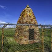
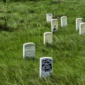
No story of Big Horn County would be complete without mentioning two events that happened there. In June, 1876, General George Armstrong Custer led the 7th Cavalry up the Little Big Horn River and engaged a group of Lakota and Cheyenne warriors in what became known as Custer's Last Stand. The battle took place near the present-day community of Crow Agency, and the National Park Service's Little Bighorn Battlefield National Monument offers walking and driving tours, as well as a visitor's center, a museum and a gift shop. Private groups perform re-enactments not affiliated with the National Park Service.
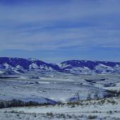
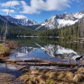
Almost 90 years later, Yellowtail Dam opened on the Big Horn River, creating Big Horn Canyon National Recreation Area. The dam, named for Crow Chair Robert Yellowtail, stands 525 feet high, and extends 1,480 feet in width. The reservoir created by the dam extends over 70 miles south and crosses into Wyoming. The lake offers excellent fishing, boating, hiking, camping, and spectacular scenery. Note that the Fort Smith, Montana-based visitor center is only open from Memorial Day to Labor Day and is closed during the fall, winter, and spring months.


Leave a Comment Here