Get to Know a County: Mineral County

On August 7th, 1914, the Montana Legislature created Mineral County, taking the western end of Missoula County and placing the seat at Superior. Covering 1,220 square miles, it is fiftieth of Montana’s 56 counties in area, and with a 2020 population of 4,880, it is the second smallest county west of the Divide. In the West, only Granite County has fewer people.
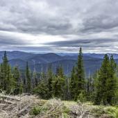
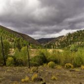
A long, narrow slice of land, Mineral County lies along the Bitterroot Mountains, bordering Idaho, with one federal highway running through its middle, Interstate 90. The interstate itself runs parallel to the St. Regis River at its western end, and to the Clark Fork River for the rest of its length in the county. There are nineteen exits from I-90 in Mineral County, and since all the populated areas are along this corridor, let’s drive west to east along the interstate as we get to know Mineral County.
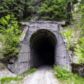
Exit 0, just east of the Idaho state line, takes you to Lookout Ski Area. A popular family resort with 38 groomed trails, Lookout Ski Area is in the process of expanding and will soon double its current size of 540 acres. The chalet is also where you buy tickets for the Hiawatha Trail, a bike/hike trail following the path of the old Milwaukee Railroad line from East Portal westward down the mountain through a series of tunnels and over trestles built originally in the early 1900s.

Exit 5, Taft, is where you leave I-90 to get to East Portal and the Hiawatha Trail. Today, a Montana Department of Transportation sanding pit is all that marks the site of what a Chicago Tribune reporter called “the wickedest city in America.” Built to serve the men building the Milwaukee Road, Taft had every accommodation a hard-working man could want back in 1908. Named for then-Secretary of War William Howard Taft, the town met its comeuppance when the devastating fires of 1910 burned Taft to the ground.
Exit 10, Saltese, takes you to an old mining town with a good reason to get off the highway. The Old Montana Bar and Café was built originally around 1910 and was a popular place among people in neighboring Idaho’s Shoshone County. The bar was open later than Idaho allowed, and the gambling went on after Idaho outlawed that activity. The original bar burned to the ground in 1996 but has since been rebuilt and serves fine meals along with its drinks. And yes, the poker machines are active again.
Exit 16, Haugan, is another Milwaukee Road town destroyed by the 1910 fire. Haugan may be the most advertised exit in Montana. Many Montana towns have a Silver Dollar Bar, but Haugan is home to The 50,000 Silver Dollar Bar. The bar, with its attached gift shop, café, and adjoining motel and gas station, is indeed home to over 50,000 silver dollars on display in the bar and around the walls. I always take guests there.

Exit 16 is also the exit for the Historic Savenac Nursery. Built in 1907 and active through 1969, the former Forest Service Nursery now serves as a picnic area and interpretive center honoring forest work and the Civilian Conservation Corps.
The next five exits, 18 through 30, serve mainly as ways for fishermen to get to the St. Regis River.
Exit 22, Henderson, does lead to the Camelback Road, the old Highway 10, which was used as a detour to St. Regis while the interstate was being built through the St. Regis River canyon.
Exit 33, St. Regis, takes you to the third largest community in the county. It is where the St. Regis River flows into the Clark Fork, and today is known primarily as the location for several different tourist facilities, including restaurants, gas stations, a motel, and gift and antique shops.
Memorial Day Weekend brings thousands of visitors to the St. Regis Flea Market—billed as Montana’s largest.

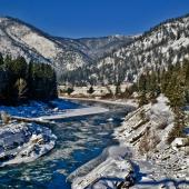
St. Regis is also the only place to catch a paved highway leading away from I-90. Montana Highway 135 has been named the St. Regis to Paradise Scenic Byway and is a beautiful drive following the Clark Fork River north and east for 21.5 miles. Only the first seven are in Mineral County.
Between St. Regis (Exit 33) and Superior (Exit 47), two exits provide access to the Clark Fork River and a few homes built along the river.
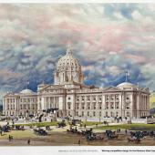
Exit 47, Superior, takes you to the county seat, a beautiful 1920 courthouse, and, on the first Saturday of June, the Old Schoolhouse Rocks Car Show, one of the largest classic car shows in western Montana. Superior, founded in 1869, grew largely because of the gold strikes in the mountains around the town. In 1908, the first Gideon Bibles were placed in the rooms of the Superior Hotel. Yes, those ubiquitous nightstand Bibles got their start in Superior, Montana.

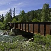
Between Superior and Alberton, five exits access the Clark Fork River and a few farms that dot the narrow valley. Exit 55, Lozeau/Quartz, takes you past the old Lozeau Bar to an historic one-lane bridge across the Clark Fork. Exit 61, Tarkio, leads you up a dirt road into one of the widest farming valleys in the county. Exit 66, Fish Creek Road, takes you to Fish Creek State Park, the second largest park in Montana’s system and home to the largest ponderosa pine in the state.
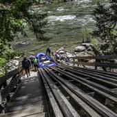
Exit 70, Cyr, is home to a raft ramp for folks who want to float the infamous Alberton Gorge on the Clark Fork River. Note that the Cyr Bridge on old Highway 10 is in serious need of repair, but you’ll have to cross it to get to the raft ramp.
Exits 75 and 77, Alberton, are the last exits for Mineral County, although technically 77 is across the line in Missoula County. Alberton, another Milwaukee Road community, is home today to a used bookstore that bills itself as the largest such establishment in Montana. I heartily recommend a visit.


Leave a Comment Here