The Little Ice Age in Montana: Its Environmental and Cultural Impact
The Little Ice Age, which primarily affected the northern hemisphere, was the coolest and wettest period since, perhaps, the Younger Dryas event ended roughly 11,700 years ago. Depending on the criteria used to identify its origin and geographical scope, climatologists commonly interpret the Little Ice Age as a regime that lasted from ca. 1300 until the mid- or late 19th century. On the other hand, environmental historians and anthropologists, especially those whose research focuses on the Plains culture area, typically frame the LIA more narrowly, limiting its boundaries to the Neo-Boreal period (1550-1850).
Of the many factors that have been identified as possible contributors to the onset and duration of the Little Ice Age, two are particularly noteworthy. Sunspots, which are a visible indicator of fluctuations in the intensity of solar radiation, have been observed telescopically by astronomers for more than 400 years, as evidenced by Galileo's drawing on June 23, 1613. Lengthy periods of low sunspot activity, notably the Spörer (1460-1550), Maunder (1645-1715) and Dalton (1790-1830) minimums, correlate highly with both the coldest portions of the LIA and concentrated periods of explosive volcanism.
A paleoclimatological study by Gifford Miller et al. (2012) presents a compelling argument that the first pulse of Little Ice Age cooling was triggered by a massive eruption of Mount Samalas (Indonesia) in 1257, followed closely by three large eruptions elsewhere during the late 13th century. Clive Oppenheimer (2011) concludes similarly that almost "half of the decadal variability seen in northern-hemisphere temperature reconstructions" for the period from 1400 to 1850 "can be attributed to volcanism." This correlation is particularly strong for the years from 1630 to 1850, when 16 major eruptions and cooling events occurred.
Given the volatility of the Little Ice Age and Montana's reputation for extreme weather, an intriguing question comes to mind: Were conditions, particularly in winter, significantly more severe in Big Sky Country during the LIA than they are today? That question, unfortunately, cannot be answered definitively.

Early Weather Records in Montana
The earliest instrumental and observational data available for the Upper Missouri, including Montana, are ultimately attributable to Thomas Jefferson. Best known, of course, as America's third president, Jefferson also maintained a lifelong interest in meteorology. Indeed, his earliest surviving weather observations were recorded at Philadelphia on those fateful days in early July 1776, when the Continental Congress formally adopted the Declaration of Independence. Twenty-seven years later, Jefferson instructed Meriwether Lewis to systematically document thermometric readings and weather observations on his forthcoming exploration of the Louisiana Territory.
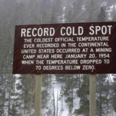
The Corps of Discovery did not enter present-day Montana until April 28, 1805, but journal entries made during the winter of 1804-1805 at Fort Mandan (North Dakota) chronicle the severity of conditions that existed then on the northern plains. They experienced a 13-inch snowfall on November 29, the coldest weather of their trip on December 17 (-45°F), and a ten-day period (January 5-14, 1805) during which overnight lows averaged -24°F.
The accuracy of meteorological instruments from that era certainly can be questioned. Nevertheless, Arlen Large compared thermometric data recorded by Lewis and Clark during January-March 1805 with the seasonal average for the same months from 1951-1980 at Bismarck, which is approximately 45 miles from the corps' encampment site. Large determined that temperatures at Fort Mandan were, on average, eight degrees lower than corresponding values from the 20th century.
Prince Maximilian of Wied compiled comparable data during the winter of 1833-1834 at Fort Clark, an American Fur Company post, located near the Mandan village of Mih-tuttah-hang-kusch, in North Dakota. His most eye-popping comment, however, presents anecdotal data. On January 30, 1834, James Kipp, the post superintendent, returned to Fort Clark from Fort Union, where "the thermometer supposedly registered -45°F for more than fourteen days."

Paleoclimatic Evidence
Without an archival record consisting of instrumental observations, paleoclimatologists utilize proxies, most commonly tree-ring and ice-core analyses, to reconstruct previous climate regimes. Brian Fagan, author of The Little Ice Age, observes that "Two cores from the Greenland ice cap, known as GISP1 and 2, are of particular interest [to researchers]. GISP-2 has an accuracy in calendar years of ± 1 percent, which makes it exceptionally useful for dating temperature changes."
Tree-ring studies, on the other hand, indicate that, from 1602-1900, winters on the plains were colder than those of designated 20th-century normal periods. The greatest temperature reduction, 5.6°F, was reported for the northeastern plains. Available evidence does not suggest that summers were significantly cooler, but the dendrochronological record confirms the premise that year-to-year fluctuations in temperature were more pronounced. This data also comports with descriptions of the Maunder Minimum as one of the coldest portions of the Little Ice Age. Indeed, Fritts, Lofgren and Gordon (1979) conclude that winters from 1651-1700 were approximately 1.8°F colder than those between 1602 and 1650.

Precipitation Patterns
Except for the northwestern plains, where a 3.1% increase in annual precipitation was extrapolated, relative to the period from 1901 to 1970, paleoclimatological reconstructions do not support arguments that the Great Plains received significantly more precipitation during the LIA. I suspect, however, that the magnitude of this anomalous data point would be amplified if additional tree-ring studies were conducted at sites located on the Rocky Mountain Front and/or the interface between the high plains and Montana's various island ranges.
One study that meets this criterion was conducted by Gregory Thomas Pederson (2004). Based on tree-ring data obtained from sites on both sides of the Continental Divide in Glacier National Park, Pederson concludes that "A succession of long-duration, high-intensity pluvial events, unsurpassed by any in the instrumental and reconstructed time series, [occurred] from 1770-1850." Indeed, statistically significant, high-precipitation intervals lasted from 1770-1791, 1800-1810, and 1818-1840, which coincides with "the height of the Little Ice Age (LIA) and glacial expansion within the park." Pederson's analysis also reveals that "the single most intense decadal-scale wet regime [prevailed from] 1800-1810." It is distinctly possible that the eruption of Mount St. Helens in 1800 contributed to this particular precipitation pattern.

The 1810s: The Coldest Decade
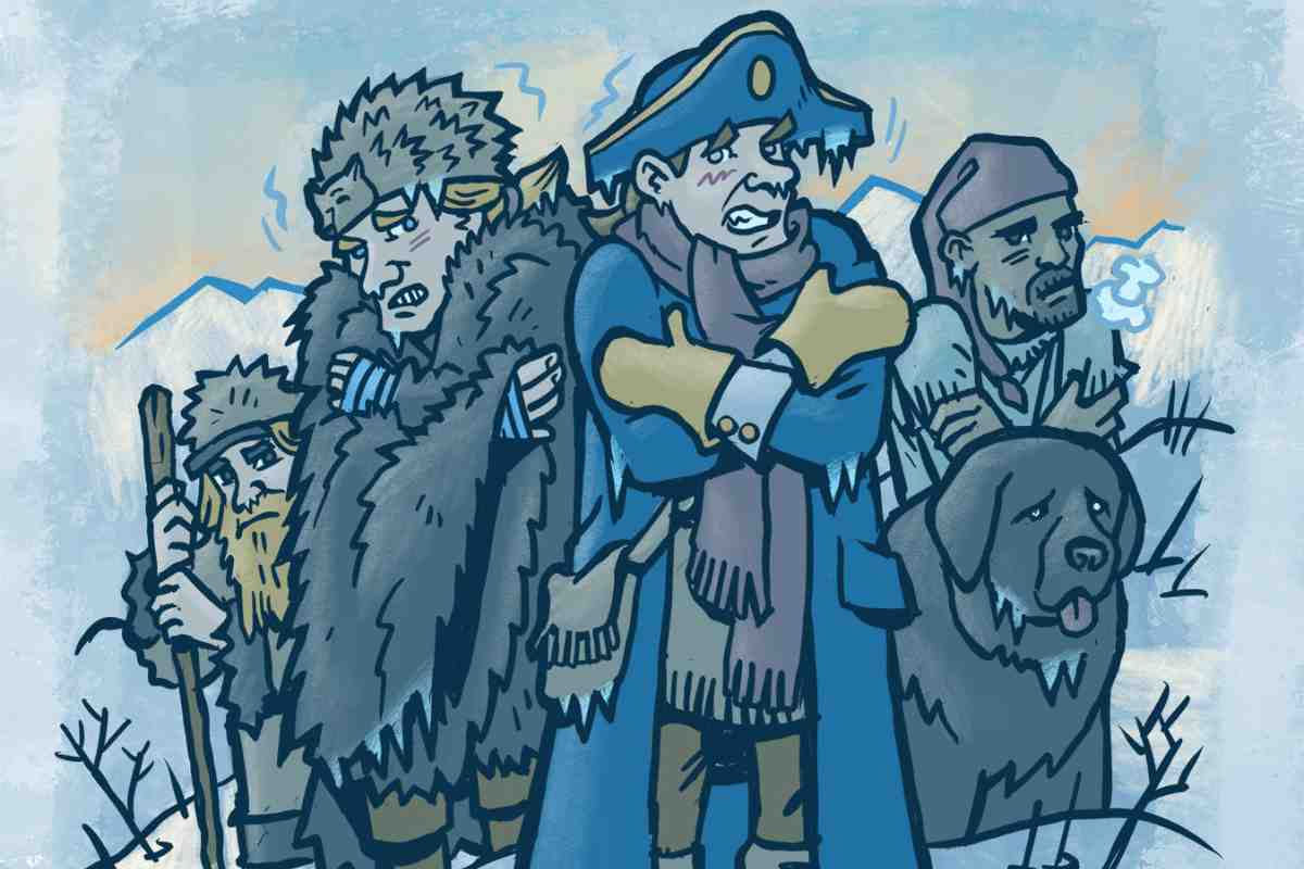
The following data may not be directly applicable to Montana, but documentary and instrumental evidence strongly suggest that the 1810s were the coldest and most volatile decade of the LIA, especially in Europe and New England. Those years were punctuated by a tightly clustered series of major volcanic eruptions, including the "Great Unknown" event of 1809, followed by Soufrière in the Caribbean (1812), Mayon in the Philippines (1814) and the cataclysmic eruption of Mount Tambora (Indonesia) in 1815.
Classified as a Volcanic Explosivity Index (VEI) 7 event, based on the estimated volume of material that it ejected, Tambora's caldera-forming eruption may have been the most powerful explosion on Earth during the last 12,000 years. It exacerbated the cooling trend initiated by preceding eruptions and, according to Gillen D'Arcy Wood, contributed to an "overall decline of global average temperatures of 1.5°F across the entire decade." Consequently, Wood characterizes the havoc that Tambora wreaked as "the most catastrophic, sustained weather crisis of the millennium." Historian John Post echoed those sentiments, when he described Tambora's aftermath as "the last great subsistence crisis in the western world."
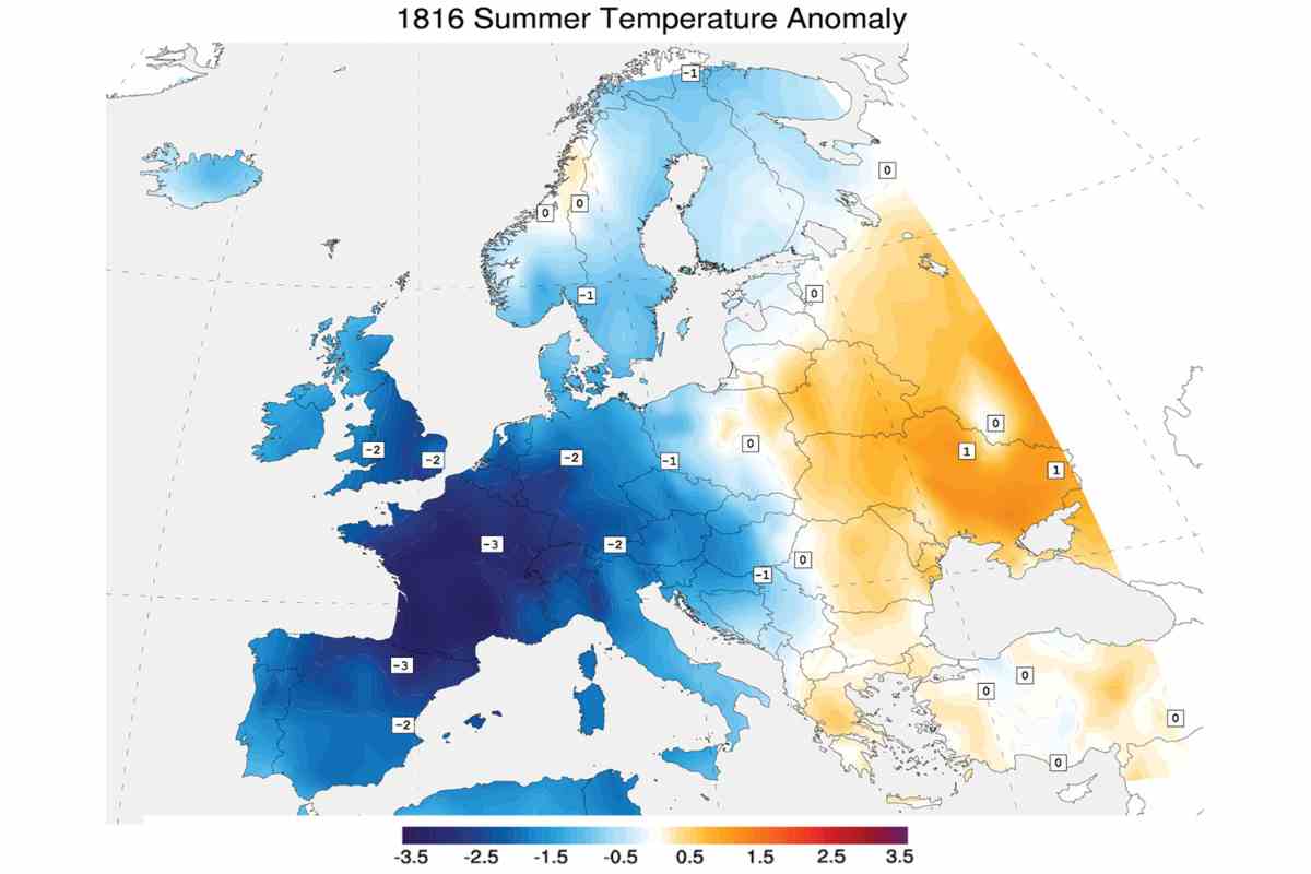
Instrumental and observational data recorded contemporaneously by Luke Howard, the English "father of meteorology," corroborate these conclusions. Daily temperatures in London from 1807-1815 averaged 50°F, a baseline already suppressed by several years of volcanic weather. That figure plummeted to 38°F in 1816, the "Year without a Summer," which New Englanders also described as "Eighteen-Hundred-and-Froze-to-Death." Shortly after Tambora-induced cooling finally dissipated, major eruptions of Zavaritskii (Kuril Islands) and Cosigüina (Nicaragua) in 1831 and 1835, respectively, reactivated atmospheric cooling.
Cultural Impact on Plains Indians
For peoples indigenous to Montana, the Neo-Boreal period coincided with the zenith of communal bison hunting, a practice initially pursued through the antecedent use of buffalo jumps. The era (1770-1850) that Pederson identifies as the climax of the LIA can be described, with equal justification, as the golden age of Plains Indians. Then sufficiently mounted, they harvested their staff of life more efficiently and could fully commit to bison-based, equestrian nomadism.
The modest increase in annual precipitation that occurred on the northwestern plains may not have been enough to maximize bison carrying capacity. However, environmental historian Dan Flores provides a superb 30,000-foot perspective that illustrates the convergence of factors which contributed collectively to the Serengeti-like landscape that Lewis and Clark witnessed. LIA conditions promoted the growth of C4 grasses, such as buffalo grass and grama grasses, which bison preferentially consume, instead of cool-season grasses. An almost mythical biomass of bison accrued at the same time that virgin-soil epidemics, introduced by the first waves of European colonialism, decimated tribal populations and reduced hunting pressures throughout much of the contiguous United States. As Flores (2016) observes, the herds eventually spilled "out of the Great Plains, both eastward across the Mississippi and westward down the Columbia and Snake River systems," from which they "squeezed like toothpaste into every nook-and-cranny prairie from Pennsylvania to Georgia, and across Oregon, Idaho and northern Utah."
When the Corps of Discovery later made their epic journey, the effect of buffer zones on game populations slowly became evident. William Clark noticed that wildlife invariably was most numerous in "country between the nations which are at war with each other." Theatres of intertribal conflict shifted geographically over time, but the Upper Missouri, particularly the plains of eastern Montana, remained the grand prize for these equestrian nomads.
The End of the Little Ice Age
Given its longevity, the Little Ice Age ended abruptly. Precipitation and forage were above average throughout much of the first four decades of the 19th century. Conditions began to deteriorate in the late 1840s, when a series of short-lived but serious droughts erupted. These events were precursors to a more severe and widespread megadrought, which raged from Texas to the Canadian Rockies.
Historical accounts and tree ring-based reconstructions consistently indicate that this event, which lasted from approximately 1858 to 1866, was the worst drought that afflicted the Great Plains in the last 300 years. Pederson specifically notes that "the most extreme single-year drought" since 1540 in present-day Glacier National Park occurred in 1868. He also emphasizes that the 1860s drought was "the most intense decadal-scale drought for numerous sites throughout the Canadian Cordillera."
Such extraordinary climatic stress may have reduced bison carrying capacity by "as much as 60 percent," according to Reid Bryson (1981). Comparative data from the dust bowl era supports his conclusion. Coupland (1958) reports that forage yield per acre in Montana dropped from 1,586 pounds in 1927 to 222 pounds in 1934.
Unfortunately, access to areas that bison normally would have sought as refuge in times of drought was severely restricted by the proliferation of permanent settlements east and west of the Great Plains. The rapid convergence of environmental and historic forces fatally undermined the sustainability of bison-based, equestrian nomadism as a subsistence strategy. In less than 30 years, the buffalo, which had sustained a succession of indigenous peoples for millennia, were on the brink of extinction.


Leave a Comment Here