Montana's Scenic Byway
Pioneer Route 73
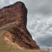
Sprawling over 3.35 million acres, eight counties and over a dozen mountain ranges, the Beaverhead-Deerlodge is Montana’s biggest national forest. At its heart rise the Pioneer Mountains—actually two ranges in one. The West Pioneers are the older, more rounded mountains (but still plenty rugged), topping out at 9,405 feet on Odell Mountain. Higher still, climb the steep, alpine East Pioneers, with the twin peaks of Torrey and Tweedy (11,147 and 11,154 feet) looming like some massive Tweedledee and Tweedledum over the lush Ruby River valley.
Slicing through the middle of this immense piece of Montana high country is the Pioneer Scenic Route, Forest Service Highway 73. This 49-mile road offers unparalleled access to mountain wilderness, rushing rivers, deep forests, wide meadows, remote lakes, ghost towns, campgrounds, and miles and miles of national forest trails. The road is open from May 15 to December 1, when it becomes a major destination for snowmobilers.
The Pioneer Scenic Byway starts in the little fly-fishing town of Wise River, along the Big Hole River, where floating and fishing are a way of life. Montana’s last population of fluvial arctic grayling survives in this river, originally called “Wisdom River” by Lewis and Clark. Crossing wide sagebrush flats, the road soon enters the mountains proper, paralleling the smaller Wise River.
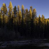
Here you will find the best of both worlds: a smooth, well-built road traversing remote mountain country. This combination draws campers, hikers, bikers, and fishers from all over western Montana. The road reaches a high point of nearly 8,000 feet, with stunning views of the granite crags and spires of the East Pioneers rising over alpine meadows and subalpine fir.
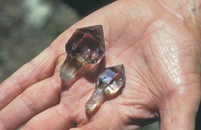
Crystal Park, near the divide between the Wise River and Grasshopper Creek, is the only mineral area set aside on National Forest System lands specifically for recreational mineral collection. People come here to explore its 220 acres for abundant and beautiful hexagonal quartz crystals.
Seven excellent campgrounds along Highway 73 ensure you can nearly always score a good campsite. I’ve stayed at Lodgepole and Grasshopper campgrounds and found both very restful. Grasshopper even has horseshoe pits.
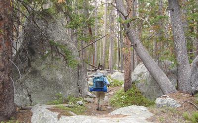
As you proceed through the Pioneers, side roads and trailheads beckon you to the back of beyond. Hiking and mountain biking in this rugged country are simply spectacular. If you are looking for challenging hiking, or even an easy stroll through the wildflowers, opportunities along the Pioneer Route are nearly unlimited.
The East Pioneers offer some challenging hiking. For an easier, one-way hike take Gold Creek Trail #152 to Trail #140, north to Trail 117 ending at Lodgpole Campground (about a four mile loop). You could drop a bike at Lodgepole and cycle back to your car on the main road. For a much more ambitious loop, set aside several days to backpack or horseback ride the Pioneer Loop National Recreation Trail #750, from Lacy Creek to Pettengill Creek. This will take you through the heart of the West Pioneers Wilderness Study Area, nearly 150,000 acres set aside by Congress in 1977 to protect its wilderness character.
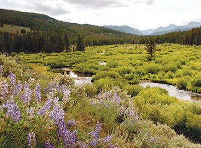
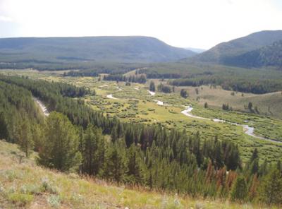
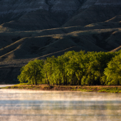
Head up nearly any side creek from the main road and you will find immense wet meadows up to four miles long. These are gifts of the glaciers that shaped this country and left moraines near the mouths of the canyons. Over time the creeks have carried down sediment from the mountains and filled in the valleys behind the moraines, forming these huge, lush meadows. Creeks meander through the grasslands, attracting beaver, muskrat, otters, moose, waterfowl, and fly-fishers.
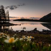
Get back deep into the West Pioneers and you can get as rugged and remote as you please. My favorite overnight hike here is Trail #50 Bobcat Creek to Bobcat Lakes. This is a fairly challenging five-mile hike in to a gorgeous lake with good camping. From the lake you can easily visit upper Bobcat Lakes and climb Bobcat Peak.
A popular backpack trip in the East Pioneers takes you up Jacobson Creek Trail # 752 to Tahepia Lake and Shultz Lakes. Pack the fishing pole for some splendid high country fishing.
These high, wild ranges shelter some of Montana’s most rare and imperiled wildlife—wolverine, wolves, mountain goats, and perhaps a few Canada lynx, a species protected by the Endangered Species Act.
The smooth pavement and extraordinary scenery along the Pioneer Route lure road bike riders from far and wide. Each June, hundreds of road bikers participate in RATPOD, Ride Around the Pioneers in One Day, a fund-raiser for Camp Mak-a-Dream, a Montana facility providing cost-free, medically-supervised positive experiences for people affected by cancer. RATPOD is a challenging 130-mile ride, beginning and ending in Dillon, with several mountain passes to negotiate. The highlight is the 49 winding miles of Highway 73.
Bring your moutain bike too. Sheep Creek Trail #216 is one of the few you can ride into the East Pioneer Mountains from Highway 73. Most trails on this side, including Jacobsen Creek and David Creek, are closed to bikes and other mechanized transport since the Forest Service set aside a large area of “recommended wilderness” in the East Pioneer Mountains. There is a better mountain biking access west of the highway, in the West Pioneer Mountains. The Lacy Creek section of the Pioneer Loop National Recreation Trail #750 offers great biking through vast meadows. It’s best to wait for this and many other trails to dry out, especially in a wet season like 2011. Pettengill Creek Trail #245 allows you to bicycle way back into the mountains on an excellent two-track. Just watch out for the big bad bovine bulls that summer back in these remote drainages! Or try Wyman Creek Road #2417 into upper Anderson Meadows and beyond.
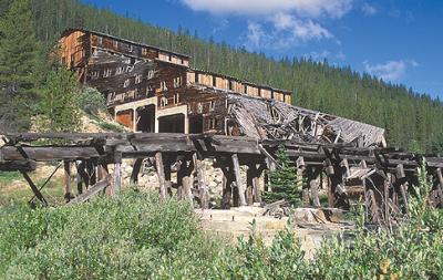
Don’t miss the ghost town of Coolidge. Named for President Calvin Coolidge, this remote mining town is now mostly in ruins, but some buildings still stand, in a swayback, unsteady fashion. Coolidge grew up around the Elkhorn and Idanha mines, dating back to 1873. Silver ore from these mines was hauled by bull teams as far as Corrine, Utah, to reach a railhead. The ore then proceeded to San Francisco, then by ship to Wales to be processed. The two mine sites at Coolidge were connected by a long chute, Locals using big frying pans slid down the chute in winter for fun! By the 1920s this town was in decline, and it now is moldering into the Montana gravel.
To find Coolidge, take Forest Service Road 2465 past Mono Creek Campground to the end of the road, then hike a half-mile to the townsite. For a hike into a wild and remote corner of the East Pioneers, continue past Coolidge on Trail 747 to Elkhorn Lake.
Grasshopper Creek flows south off the high country, and the Pioneer Mountains Scenic Byway follows this drainage past Elkhorn Hot Springs and Maverick Mountain ski area through the resort area of Polaris. Plan on a soak at Elkhorn Hot Springs, a funky, friendly resort that has escaped the gentrification or overdevelopment of some Montana resorts. Finish your Pioneer journey with a visit to Bannack State Park and relive Montana’s wild, lawless gold rush days at the most well-preserved ghost town in the state.
~ Phil Knight is an outspoken conservationist, backcountry explorer, musician, poet, and world traveler. Phil’s passion and lifelong avocation is protecting and exploring wild places and seeing and learning about wild creatures. In doing so, he has fallen out of several trees. Phil lives in Bozeman, Montana, with Alaina, his wife of 15 years.


Leave a Comment Here