Get To Know Blaine County

On February 29th, 1912, the Montana State Legislature created Blaine County from the northeastern portion of Chouteau County. Three years later the eastern part of the new county became western Phillips County. Since then Blaine County’s boundaries have remained the same--a slightly irregular rectangle stretching roughly 90 miles from the Canadian border to the Missouri River and approximately 60 miles east to west. The county covers 4,267 square miles and as of the 2020 U.S. census had 7,044 residents. Like many eastern Montana counties, Blaine County’s population was much greater in its first census (1920) and the 1940 census recorded the highest number of residents in the county’s history.
The county takes its name from Maine representative and senator James G. Blaine, who also is the man for whom Blaine County, Idaho is named. On a side note, the James G. Blaine Society is a fictional organization dedicated to keeping Oregon free from new residents. It is so named because in 1884, Blaine, running for president, visited every state in the union except Oregon. I can only guess that Montana Republicans chose to honor Senator Blaine as a leading Republican politician.
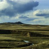
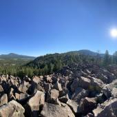
Topographically, Blaine County is mostly flat with many coulees in the north half of the county. The Bears Paw Mountains and associated buttes cross through the middle of the county east to west. The Little Rocky Mountains rise in the southeastern corner of the county. The Milk River, U.S. Highway 2, and the Great Northern Railroad (now the Burlington Northern Santa Fe Railroad) cross through the middle of the county east to west. You will be forgiven if you misspell the name of Blaine County’s most prominent feature: the Bears Paw Mountains. No less authority than the U.S. Geological Survey gives four separate spellings for this mountain range that rises to 4,600 feet and crosses most of central Blaine County.

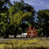
Chinook, the Blaine County seat, sits on the Milk River in the western part of the county. With a 2020 population of 1,185, it is the second smallest county seat on U.S. Highway 2, Montana’s Hi-line. It is not even the largest population center in Blaine County. That would be Fort Belknap Agency, some 25 miles east on Highway 2. Chinook is home to the Blaine County Museum, the Blaine County Wildlife Museum, and a great assortment of Art Deco architecture spread around the town.
The Blaine County Museum features exhibits of native life, cowboy and homestead-era life and life in Blaine County through two world wars. It is also a site on the Montana Dinosaur Trail with a dozen Judith River Formation exhibits. The museum, located at 501 Indiana Street, offers free admission and is open year-round with reduced hours from October 1st to April 30th.
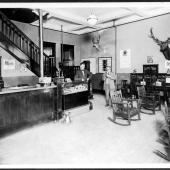
The Blaine County Wildlife Museum, at 417 Indiana Street, is housed in what used to be the town's Blaine Theater. Open from June 1st through August 31st, hours are nine to five Monday through Saturday and one to five on Sunday. Exhibits include several dioramas and many animal mounts that bring the wildlife and landscapes of Blaine County together in one place.
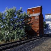
On the east side of the town a smokestack rises. It is the most visible remnant of the old Utah and Idaho Sugar Company’s refinery that was built in 1925 and closed in 1952. Built originally on a site chosen for its proximity to the railroad and the Milk River, a further contributing factor was the number of German immigrants living in the area who had experience growing sugar beets. The refinery is long gone, but its memory lingers on not just with the smokestack but with the name of the Chinook High School teams, the Sugarbeeters.

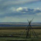
Roughly 15 miles south of Chinook, you will find one unit of the Nez Perce National Historic Park. The park, also known as the Nee-Me-Poo Trail, commemorates the 1877 trek made by 750 Non-Treaty Nez Perce Indians from Joseph, Oregon to the Bears Paw Mountains. At this location, just 40 miles south of the Canadian border, Chief Joseph made his famous “I will fight no more forever” speech. The park includes an interpretive trail, picnic tables, and the parking area, but no overnight camping. The Blaine County Museum offers a multimedia presentation ‘40 Miles from Freedom’ which describes the battle and siege that took place here in October 1877.
The Fort Belknap Reservation covers most of southeastern Blaine County. The reservation, established in 1888, was set aside for the Assiniboine and Gros Ventre tribes. Montana Highway 66 crosses the reservation from north to south and connects Fort Belknap Agency with the town of Hays near the Little Rocky Mountains. The reservation’s headquarters, Fort Belknap Agency, is the largest population center in the county with a 2020 census count of 1,567 people. Located at the junction of U.S. Highway 2 and Montana State Highway 66, the town is home to Aaniiih Nakoda College, one of Montana’s seven tribal colleges, as well as tribal governmental offices.
If you are out for a road trip, you will have no trouble driving around Blaine County. In addition to U.S. Highway 2 and Montana Highway 66, there are there are numerous roads crisscrossing the county including six of Montana's secondary highways. Montana Secondary 240 connects Chinook with the ghost town of Cleveland in the foothills of the Bears Paw Mountains. Montana Secondary 241 connects Harlem with the Canadian border at the Port of Turner. Other secondary roads will take you to Coburg and Hogeland, while Savoy, Harlem, Zurich, and Lohman are all on Highway 2. One road I cannot recommend starts at Hays and climbs into the Little Rocky Mountains following, and sometimes fording, Little People Creek. When I took the drive in the late 1970s, I expected to end up in the mining camp of Landusky. Instead, I stopped at a locked gate high in the Little Rocky Mountains where I had to turn around and retrace my route back to Hays, again fording the creek several times. Do not try this without a rugged 4-wheel drive vehicle.
To close, I would be remiss if I did not mention the Upper Missouri Breaks National Monument and the Missouri National Wild and Scenic River which form the southern border of Blaine County. Both are accessible by road and offer a multitude of recreational opportunities.


Leave a Comment Here