That Rumble May Not Be Your Tummy
 A new federal earthquake map dials up the shaking hazard just a bit for about half of the United States and lowers it for nearly a quarter of the nation.
The U.S. Geologic Survey (USGS) updated its national seismic hazard maps on Thursday for the first time since 2008, taking into account research from the devastating 2011 earthquake and tsunami off the Japanese coast and the surprise 2011 Virginia temblor.
The maps are an important part of the National Earthquake Hazards Reduction Program, a partnership of four federal agencies to reduce risks of earthquakes. The four agencies include USGS, the Federal Emergency Management Agency (FEMA), the National Institute of Standards and Technology, and the National Science Foundation.
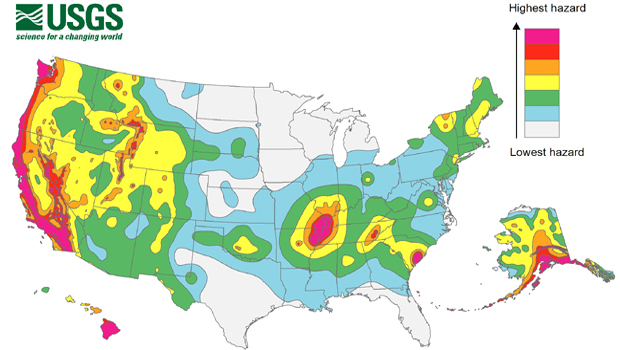
Most high-risk zones are concentrated on the west coast and Alaska, with a few other hotspots clustered around faults in the Midwest and Southeast.
Most of the changes in this year's updated map are relatively minor. Project chief Mark Petersen said parts of Washington, Oregon, Utah, Oklahoma, Colorado, Wyoming and Tennessee moved into the top two hazard zones.
Parts of 16 states have the highest risk for earthquakes: Alaska, Hawaii, California, Oregon, Washington, Nevada, Utah, Idaho, Montana, Wyoming, Missouri, Arkansas, Tennessee, Illinois, Kentucky and South Carolina.
MORE>>>CBS
Leave a Comment Here